





































































How Bangladesh Doubled Its Size
Securing the maritime area was only the beginning. Bangladesh must now protect the area, ensure maritime security, safeguard its environment, and develop the capacity to explore and responsibly utilize the resources of the seabed and subsoil.


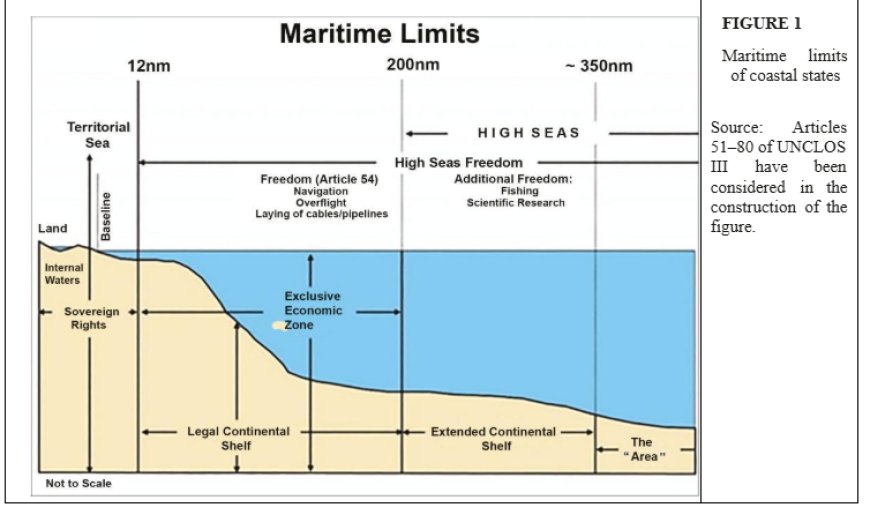
The United Nations Convention on the Law of the Sea (UNCLOS) establishes the international legal framework under which coastal states may claim maritime zones. A coastal state is generally entitled to an Exclusive Economic Zone (EEZ) extending up to 200 nautical miles from its baseline.
Where a state seeks to establish rights beyond 200 nautical miles, as in the case of Bangladesh’s claim extending to approximately 350 nautical miles, scientific and technical data must be submitted in accordance with the relevant provisions of UNCLOS (Figure 1).
Bangladesh had begun asserting its maritime rights even before the UNCLOS framework was formally established. In general, maritime boundaries are determined through two complementary processes.
First, the outer limits of maritime zones are established in accordance with international law, including the relevant provisions of UNCLOS and, where applicable, the work of the Commission on the Limits of the Continental Shelf (CLCS).
Second, maritime boundaries between neighbouring states are normally settled through negotiation and dialogue and, when agreement cannot be reached, through arbitration or adjudication.
Bangladesh attempted both approaches. Teams from Bangladesh held numerous discussions and meetings with both India and Myanmar, but no mutually acceptable settlement could be reached. Under these circumstances, Bangladesh ultimately had no practical alternative but to seek judicial or arbitral settlement of its maritime boundaries with its two neighbouring states.
The International Tribunal for the Law of the Sea (ITLOS), based in Hamburg, Germany, delivered its judgment on the Bangladesh-Myanmar maritime boundary dispute on March 14, 2012. Subsequently, the Permanent Court of Arbitration (PCA), based in The Hague, delivered its award on the Bangladesh-India maritime dispute on July 7, 2014. These two decisions confirmed Bangladesh’s maritime boundaries and represented an outstanding national achievement.
The significance of these judgments goes far beyond the drawing of lines on a map (Figure 2).
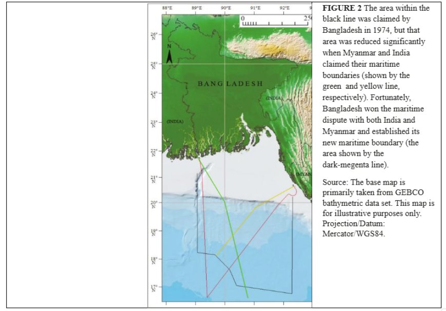
Together, they secured approximately 118,813 square kilometres of maritime area for Bangladesh, including its territorial sea and Exclusive Economic Zone. In effect, an enormous new economic and resource domain was added to the country. The area may rightly be regarded as comparable to a “New Bangladesh” -- a vast maritime space capable of contributing to the country’s economic development for generations.
The achievement, however, also created a major responsibility. Securing the maritime area was only the beginning. Bangladesh must now protect the area, ensure maritime security, safeguard its environment, and develop the capacity to explore and responsibly utilize the resources of the seabed and subsoil.
The economic, commercial, environmental, and strategic interests involved are enormous. Recognizing this potential, the Government of Bangladesh approved in principle the draft Bangladesh Maritime Zones Act 2019 on November 25, 2019.
The proposed legislation sought to strengthen Bangladesh’s maritime legal framework, promote the development of the Blue Economy, and address unlawful activities at sea, including piracy and pollution.
It also addressed Bangladesh’s rights over its extended continental shelf beyond 200 nautical miles, including the claim extending to approximately 350 nautical miles that remains under consideration by the CLCS.
The Formation of the UNCLOS Team
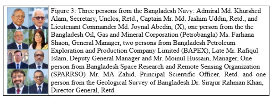
The UNCLOS team of Bangladesh was officially formed in 2001 (Figure 3). Initially, a few officers joined the team, followed by additional officers several months later, as Bangladesh prepared and submitted preliminary scientific data concerning its maritime claim to the United Nations.
The submission was accepted for consideration in accordance with the relevant criteria. The next challenge was far more demanding: Bangladesh had to prepare the complete scientific, technical, legal, and cartographic documentation required for the final submission.
At that stage, however, the task was largely unfamiliar to us. Experts from different departments, directorates, and ministries who were involved in determining Bangladesh’s maritime boundaries needed time to understand the requirements.
Even our leaders and senior experts did not initially have a clear roadmap. Although a state normally has ten years following its preliminary submission to complete the necessary scientific work and prepare its final submission, we did not know exactly how such a complex document should be structured or where the process should begin.
Various trial-and-error approaches were attempted. Yet the problem was not simply the collection of scientific information. We had to understand how enormous quantities of scientific, technical, legal, geological, hydrographic, and cartographic information could be integrated into a single coherent and convincing submission.
Throughout this difficult period, the Ministry of Foreign Affairs provided the team with the facilities, logistical arrangements, and institutional support necessary to carry out the work.
Whatever resources and assistance were required were made available to enable us to undertake this unprecedented national responsibility.
A decisive turning point came when a few exceptionally capable, farsighted, and dedicated officials of the Ministry of Foreign Affairs established contact between our team and the Southampton team of the United Kingdom.
The Southampton team had already assisted in preparing submissions for more than twenty countries. Their experience proved invaluable.
Until that point, we had determination and commitment, but limited practical knowledge of how such a complicated submission should actually be prepared.
Through repeated consultations, guidance, and examples from the Southampton team, we gradually began to understand the nature, scope, sequence, and magnitude of the work. What had initially appeared to be an almost impossible undertaking slowly acquired a clear direction and structure.
Years of Intensive Work
From that moment, we became completely immersed in the assignment. The work demanded extraordinary concentration, perseverance, and commitment. Day and night often seemed to merge. We could become so absorbed in the work that we hardly noticed when evening turned into night.
I had been associated with the team from its early stages -- or, more precisely, I had already been working with the team for nearly two years before this particular phase began. The workload was exceptionally demanding and often physically and mentally exhausting.
I would normally begin work at around 9am and frequently remain at the office until 10 or 11 at night.
Looking back, those were undoubtedly some of the most demanding years of our professional lives. Yet they were also among the most meaningful. We learned while working, overcame one difficulty after another, and gradually transformed an unfamiliar and seemingly impossible assignment into a structured national endeavour.
At our first meetings, we were told that everything discussed within the team was strictly confidential. The confidentiality was so stringent that we were not even permitted to discuss the details with our spouses.
Personnel involved in the work were required to obtain security clearances from the relevant security agencies. The work therefore carried not only scientific and technical responsibilities but also a high level of national security and confidentiality.
The preparation process involved repeated meetings and consultations with marine experts from different countries. We gradually prepared individual chapters, which were eventually brought together into the final submission concerning Bangladesh’s maritime boundaries.
The entire process required years of scientific investigation, data verification, technical analysis, legal interpretation, and painstaking review.
Although the general time frame for preparing such a submission was ten years, the work ultimately extended over a longer period because of the need to revise and refine the original scientific data.
Despite these enormous challenges, Bangladesh succeeded in completing and submitting its report within the required framework.
The Maritime Boundary Verdicts
The maritime boundaries with our neighbouring countries had initially been expected to be settled through negotiations. Bangladesh made repeated efforts to achieve such settlements with India and Myanmar.
When those efforts failed, Bangladesh approached international tribunals. The resulting decisions ultimately secured approximately 118,813 square kilometres of maritime area for the country.
Preparing the submission itself was an immense undertaking. Every word, line, figure, coordinate, and piece of supporting information had to be carefully examined. Even a seemingly simple word could have a different legal or technical meaning depending on the context. The entire team therefore worked with exceptional care and dedication.
The true reward came when our work was presented to the United Nations, and the submission was selected as a case study. For those of us who had spent years preparing it, this recognition provided a profound sense of accomplishment.
I must make special mention of our team leader, Admiral Mohammad Khorshed Alam. Without his cooperation, guidance, leadership, and unwavering support, it is doubtful whether this enormous national task could have been completed successfully.
Most members of the team who contributed to this historic work have since retired from government service, and one of our colleagues has already passed away.
We do not know whether all of us will live long enough to see the day when our work is finally presented and defended before the United Nations, or whether we ourselves will ever have the opportunity to participate in that process. Nevertheless, the work must continue. The next generation will inherit this responsibility and carry it forward.
A Historic Achievement for Bangladesh
Bangladesh has already secured judgments from two international tribunals concerning the delimitation of its maritime boundaries. Therefore, the remaining process concerning the United Nations should be understood primarily as a formal procedural step rather than a reopening of the boundaries already settled by international adjudication.
A coastal state establishes its maritime boundaries only once in its history. Once those boundaries have been conclusively determined through the appropriate international legal mechanisms, they become an enduring foundation for the country's future.
This is why Bangladesh’s maritime achievement is so important: It is not merely an achievement of one government or one generation. It belongs to the nation and will remain significant for generations to come.
Unfortunately, Bangladesh did not celebrate this historic achievement with the magnitude it deserved. The country could have marked the occasion with great national pride and recognition of the people who worked for years to secure this extraordinary national asset.
But history does not depend upon ceremonies. Bangladesh has secured its place on the maritime map of the world. The sea secured through the efforts of one generation will belong to generations of Bangladeshis yet unborn.
More Than the Discovery of Minerals
The discovery of minerals such as iron, gold, oil, or natural gas is unquestionably a major scientific and economic achievement. The discovery and subsequent exploitation of such resources can strengthen a country's economy, while the discovery itself provides immense satisfaction to the scientists, researchers, engineers, and others whose efforts made it possible.
But there is a fundamental difference between discovering resources within an established national territory and securing legal rights over a vast and previously uncertain expanse of ocean, seabed, and subsoil.
When minerals are discovered within a country's internationally recognized territory, there is generally no fundamental question concerning the country's territorial rights over that land. The resources already exist within an area over which the state exercises sovereignty.
Establishing maritime rights is fundamentally different. It requires much more than scientific discovery. It involves international law, diplomacy, scientific research, geological and hydrographic evidence, technical expertise, historical information, cartography, and negotiations with neighbouring coastal states and international institutions.
For this reason, determining and securing maritime boundaries under international law is arguably far more complex than discovering mineral resources within an established national territory.
Bangladesh’s acquisition of approximately 118,813 square kilometres of maritime area, together with the seabed and subsoil beneath it, is therefore an achievement of extraordinary national significance.
It has created an enormous domain from which the country may derive economic, scientific, environmental, and strategic benefits for generations.
Now ask yourself: Can the discovery of minerals within a country's existing territory truly be considered equal to legally securing a vast expanse of ocean from which Bangladesh can potentially benefit from marine resources for generations to come?
And that is not all. With future exploration, scientific advancement, and improved technology, these maritime areas may also reveal valuable deposits of oil, natural gas, and other resources.
The discovery of minerals is undoubtedly a great scientific achievement. But securing the legal rights to an enormous maritime domain is an achievement of an entirely different magnitude -- one that creates opportunities not only for the present generation but also for generations yet unborn.
That is the true significance of Bangladesh’s maritime achievement. We did not merely draw a line on a map. We secured a national inheritance beneath and beyond the sea -- an inheritance whose full value may only be understood by future generations.
Sirajur Rahman Khan is the Director General (Retd), Geological Survey of Bangladesh, and Ex-Professor of the Department of Oceanography, University of Dhaka.