


What Did the Dhaka Earthquake Mean?
The November 21 earthquake was unprecedented in our recent memory. What does this mean for the future of the city, how prepared are we, and what needs to be done now?

At 10:38AM local time on November 21, a powerful earthquake jolted central Bangladesh, with its epicenter in Madhabdi, Narsingdi -- just over 13km east of Dhaka’s Agargaon seismic center.
According to the Bangladesh Meteorological Department (BMD), the quake registered a magnitude of 5.7 on the Richter scale.
The US Geological Survey (USGS), on the other hand, measured it at 5.5, placing the hypocenter at a depth of approximately 10 km.
Ground Experience
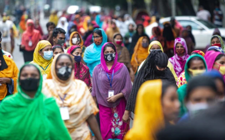
Residents of Dhaka Metropolitan City and its surrounding areas had never experienced such a powerful jolt in their lifetimes -- perhaps not even in the past century. During previous tremors, people usually noticed only a gentle swaying of objects. But this time the shaking was dramatically stronger: buildings rocked like pendulums for several seconds, and many found it difficult to stand without gripping furniture or door frames for support.
There was no time to seek shelter. The shaking came suddenly, and many of us froze in place -- too shocked to react. In my own home, I gripped an almirah for support; in other places, people leaned against doors. The tremor felt sustained, not just a brief shake.
Damage and Casualties
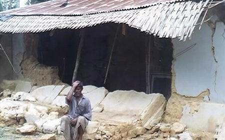
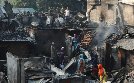
Fortunately, despite the ferocity of the tremor, the structural collapse was limited, and widespread building collapse was averted. Nevertheless: Initial reports say at least 10 people died. Over 300 people were injured. Several buildings developed cracks or tilted, including older structures.
In Dhaka, damage was reported in areas such as Bangshal, Armanitola, Matuail, Khilgaon, Hatirjheel, Kalabagan, and New Market. Factories in Gazipur saw chaotic evacuations; according to reports, locked gates trapped workers as they scrambled out. Still, despite the scale of shaking, some experts have called the overall damage “relatively limited” compared to what might have been expected for such a tremor.
Geological Context
Although Bangladesh is not located on a major tectonic plate boundary, the region has active deep-seated faults that can generate significant earthquakes. In particular, the Sitalakhya Fault (not previously known) has been identified as a likely source of the recent quake.
These faults represent deep fractures in the Earth’s crust; when stress builds up over time, sudden adjustments along these fractures can trigger earthquakes.
Geologists believe this quake was shallow, occurring around 10 km below the surface. Shallow quakes tend to produce stronger shaking at the surface, which may explain why people in Dhaka felt the tremor so acutely.
Some seismologists have suggested that the quake may have occurred "at the junction of two plates on the Indo-Burma tectonic plate."
This is a notable observation, given that traditionally, Bangladesh is not mapped as having active plate boundaries in this region.
There has also been academic debate. A previous Nature Geoscience paper postulated a plate boundary around Bangladesh -- a controversial claim, since many geological and tectonic maps (from institutions such as GSB, USGS, GSI, DU, and RU) do not show such a boundary. This discrepancy underscores how much more geological investigation is needed in the region.
Prediction, Preparedness, and Risk
Earthquake prediction remains elusive. Despite decades of research, scientists have not found reliable, short-term prediction methods -- and this quake reinforces that challenge.
Some researchers have tried to look at animal behavior (e.g. cats) for early warning signs. Indeed, there are anecdotal reports (and even viral videos) of a cat seeming to sense something just seconds before the quake -- but such signals are not consistent, controllable, or fast enough to serve as a public warning system.
Importantly, much of Bangladesh’s infrastructure -- including factories, bridges, housing, and critical facilities -- was designed to tolerate earthquakes up to magnitude 7.0.
But if a much larger quake were ever to occur (e.g. magnitude 9.0, as sometimes speculated by worst-case models), much of this infrastructure might be at serious risk.
Given the quake’s close proximity to Dhaka, and the high density of the city, the potential for damage in a larger earthquake scenario is a significant concern, both for public safety and for economic confidence (especially for investors in mega-projects).
Aftershocks and Future Risk
So far, 3 minor aftershocks have been reported. According to many seismologists, deep crustal faults typically produce fewer aftershocks, compared to boundary-zone earthquakes.
While social media and public discussion may be rife with speculation, panic is not yet scientifically justified. Once accumulated tectonic energy is released by a quake, it often takes a long time to rebuild again, meaning a comparable tremor in the very near future is less likely from the same source, though not impossible.
That said, government and geological agencies must act now: this event should be a wake-up call. Detailed seismic and geophysical studies are urgently needed -- including mapping sub-surface fault lines, improving building codes, and enhancing early-warning or rapid-response mechanisms.
What Needs to Be Done
The head of the Interim Government of Bangladesh has taken an important and timely initiative in response to the earthquake that occurred on the morning of November 21 near Dhaka. Most of the experts present at the related event were academicians.
At present, Bangladesh has only a small number of earthquake-hazard specialists working in government institutions such as the Geological Survey of Bangladesh.
Fortunately, we also have other government organizations -- such as BAPEX, a subsidiary of Petrobangla, and the Bangladesh Water Development Board (BWDB) -- that possess extensive and valuable datasets.
These include seismic records, borehole information, and water-extraction data covering large parts of the country.
Such data are essential for understanding subsurface faults, plate boundaries, and overall tectonic activity.
Accurate earthquake prediction of any magnitude requires not only long-term GPS monitoring but also detailed geophysical surveys (extending beyond the basement), borehole investigations for 3D basin modeling, water-extraction analyses, outcrop interpretations, and the study of historical earthquake records from the region.
Considering these needs, it is crucial to form a specialized team comprising both professional and academic experts to assess the country's seismic hazards. This team should provide the government and the public with realistic assessments of earthquake risks. By doing so, it would reduce the spread of misinformation, lessen public anxiety, and help the government respond more effectively and swiftly during such emergencies.
This earthquake was unprecedented in our recent memory. For someone who has lived in Dhaka for nearly half a century, feeling such a sustained, forceful shake is deeply unsettling. Yet, while the human and material toll is real, things could have been worse -- and for that, we may count ourselves somewhat fortunate.
Still, this event highlights serious vulnerabilities. It is now more important than ever for scientific institutions, the government, and urban planners to reassess seismic risk in Dhaka and its surroundings. Investing in rigorous fault-mapping, retrofitting infrastructure, and improving emergency preparedness is not just prudent -- it is urgent.
Sirajur Rahman Khan is the Director General (Retd), Geological Survey of Bangladesh, and Ex-Professor of the Department of Oceanography, University of Dhaka.
What's Your Reaction?